The Excessive Heat Warning and Heat Advisory continue through Friday. Expect another dangerously hot August day with a chance of some scattered afternoon thunderstorms. Check the video forecast for the latest.BLAZING HOT FRIDAYAn Excessive Heat Warning is in effect for Jefferson, Tuscaloosa, Cullman, Walker, Bibb, Winston, Marion, Fayette, Lamar, Pickens, Greene, Hale, and Sumter Counties on Friday. A Heat Advisory covers the rest of Central Alabama, including the Anniston-Gadsden area.Thunderstorms will be scarce for the rest of Thursday evening, but they get heavy in a few isolated areas through 9 p.m. Those getting a quick downpour also get a cooling breeze, and that helps knock the temperature down a little for Friday. No rain means no real change in the heat: still blazing Friday, Saturday, and Sunday.Friday starts out in the 70s with a clear sky and warms to the upper 90s again. The Excessive Heat Warning is for areas where the apparent temperature (heat index) gets near or above 110 degrees on Friday. The chance of a storm or two exists from around 2 p.m. to 9 p.m. Friday, so a few high school games could get some rain before or during the first half. The sweltering heat remains throughout the games, though, feeling like the 90s even through halftime.IMPACT WEATHER WEEKEND: HEAT AND STORMSSaturday and Sunday both look very hot. It will be dangerously hot, with high temperatures near 100 degrees and a heat index from 102 to 110 degrees. There also exists the chance of some scattered, potentially strong summer thunderstorms this weekend.It is just plain hot away from any storms. Whether it rains on you or stays bone dry, the nearby storms do help slowly reduce the heat a little each day through Monday.That’s their job: take hot air near the ground, take it up, cool it, and send it back down the surface. As that rain-cooled air spreads out, it helps take the edge off the heat for all of us.Be alert to the threats these storms can bring: Gusty winds over 40 miles per hour Blinding heavy rainfall Intense, frequent lightningRemember to stay indoors anytime lightning is within 10 miles of your location. Several Alabamians have been struck by lightning this summer; don’t be the next one.HEAT WAVE BREAKINGIf Birmingham fails to reach 100 degrees by Sunday, this would be one of the oddest heat waves in recent history. The potential has been there for surface temperatures in the 100s for several days, but a few factors like the heavy rain in early August (and lush green vegetation it created), the thick haze and an easterly wind have kept us from reaching that mark in the city. Thunderstorms increase ahead of a cool front Monday and Tuesday, and that front ushers in a much more moderate air mass for late August. Instead of the upper 90s and heat indices above 105 degrees, we expect highs in the upper 80s and lower 90s, overnight lows in the 60s, and lower humidity toward Wednesday and Thursday of next week.Don’t call it a ‘cool down.’ That may not accurately describe the weather, but it certainly does look a lot less sweaty next week.TROPICAL UPDATETropical Storm Franklin passed north of The Dominican Republic Thursday, and it is headed for open water where it can grow into a hurricane north of the Bahamas this weekend. This storm poses no immediate threat to the United States, but there is a slim chance it could brush Bermuda by Monday night.The next item to watch for the South comes from Central America. A disturbance that originated over the Pacific moves over El Salvador, Guatemala and Belize into the western Caribbean this weekend, and the National Hurricane Center tags it with a 60% probability of becoming a tropical depression or tropical storm by the first of next week.The cool front (and associated jet stream energy) could interfere with this system’s progress and shred it to pieces before it can build into something strong; however, some guidance gives it enough of a chance to be wary of it in Central and South Florida. It does not look like a coastal Alabama or Northwest Florida issue. CLICK TO SEE THE 7-DAY FORECASTSTAY WEATHER AWARE For the latest Birmingham weather information and central Alabama's certified most accurate forecast, watch WVTM 13 News.Current Weather ConditionsHourly Forecast | 10-Day ForecastInteractive RadarBirmingham SkycamsLive Doppler RadarSign Up For Email Weather AlertsDownload the WVTM 13 AppDon't forget to follow us on Facebook, Twitter and Instagram.
The Excessive Heat Warning and Heat Advisory continue through Friday. Expect another dangerously hot August day with a chance of some scattered afternoon thunderstorms. Check the video forecast for the latest.
BLAZING HOT FRIDAY
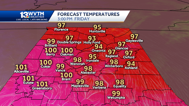
An Excessive Heat Warning is in effect for Jefferson, Tuscaloosa, Cullman, Walker, Bibb, Winston, Marion, Fayette, Lamar, Pickens, Greene, Hale, and Sumter Counties on Friday. A Heat Advisory covers the rest of Central Alabama, including the Anniston-Gadsden area.

Thunderstorms will be scarce for the rest of Thursday evening, but they get heavy in a few isolated areas through 9 p.m. Those getting a quick downpour also get a cooling breeze, and that helps knock the temperature down a little for Friday. No rain means no real change in the heat: still blazing Friday, Saturday, and Sunday.
Friday starts out in the 70s with a clear sky and warms to the upper 90s again. The Excessive Heat Warning is for areas where the apparent temperature (heat index) gets near or above 110 degrees on Friday.

The chance of a storm or two exists from around 2 p.m. to 9 p.m. Friday, so a few high school games could get some rain before or during the first half. The sweltering heat remains throughout the games, though, feeling like the 90s even through halftime.
IMPACT WEATHER WEEKEND: HEAT AND STORMS
Saturday and Sunday both look very hot. It will be dangerously hot, with high temperatures near 100 degrees and a heat index from 102 to 110 degrees. There also exists the chance of some scattered, potentially strong summer thunderstorms this weekend.
It is just plain hot away from any storms. Whether it rains on you or stays bone dry, the nearby storms do help slowly reduce the heat a little each day through Monday.
That’s their job: take hot air near the ground, take it up, cool it, and send it back down the surface. As that rain-cooled air spreads out, it helps take the edge off the heat for all of us.
Be alert to the threats these storms can bring:
- Gusty winds over 40 miles per hour
- Blinding heavy rainfall
- Intense, frequent lightning
Remember to stay indoors anytime lightning is within 10 miles of your location. Several Alabamians have been struck by lightning this summer; don’t be the next one.
HEAT WAVE BREAKING
If Birmingham fails to reach 100 degrees by Sunday, this would be one of the oddest heat waves in recent history. The potential has been there for surface temperatures in the 100s for several days, but a few factors like the heavy rain in early August (and lush green vegetation it created), the thick haze and an easterly wind have kept us from reaching that mark in the city.
Thunderstorms increase ahead of a cool front Monday and Tuesday, and that front ushers in a much more moderate air mass for late August. Instead of the upper 90s and heat indices above 105 degrees, we expect highs in the upper 80s and lower 90s, overnight lows in the 60s, and lower humidity toward Wednesday and Thursday of next week.
Don’t call it a ‘cool down.’ That may not accurately describe the weather, but it certainly does look a lot less sweaty next week.
TROPICAL UPDATE
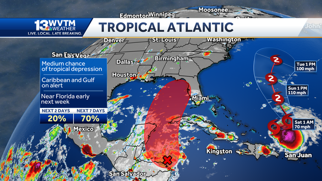
Tropical Storm Franklin passed north of The Dominican Republic Thursday, and it is headed for open water where it can grow into a hurricane north of the Bahamas this weekend. This storm poses no immediate threat to the United States, but there is a slim chance it could brush Bermuda by Monday night.
The next item to watch for the South comes from Central America. A disturbance that originated over the Pacific moves over El Salvador, Guatemala and Belize into the western Caribbean this weekend, and the National Hurricane Center tags it with a 60% probability of becoming a tropical depression or tropical storm by the first of next week.

The cool front (and associated jet stream energy) could interfere with this system’s progress and shred it to pieces before it can build into something strong; however, some guidance gives it enough of a chance to be wary of it in Central and South Florida. It does not look like a coastal Alabama or Northwest Florida issue.
CLICK TO SEE THE 7-DAY FORECAST
STAY WEATHER AWARE
For the latest Birmingham weather information and central Alabama's certified most accurate forecast, watch WVTM 13 News.
- Current Weather Conditions
- Hourly Forecast | 10-Day Forecast
- Interactive Radar
- Birmingham Skycams
- Live Doppler Radar
- Sign Up For Email Weather Alerts
- Download the WVTM 13 App
Don't forget to follow us on Facebook, Twitter and Instagram.

 1 year ago
30


 English (US)